In general, the federal Voting Rights Act requires states to draw majority-minority districts as long as they are compact and respect communities of interest. What might congressional maps of the 5 “deep south” states look like if this were not required?
All 5 of Louisiana, Mississippi, Alabama, Georgia, and South Carolina are entirely controlled by the GOP now. These maps follow the principle of “what would the RNC do” to maximize the expected number of GOP seats, as happened in North Carolina and Ohio. In practice it's possible that incumbents and their allies in state legislatures would be reluctant to weaken their districts and thereby let some Dems wiggle off the hook, as happened in Tennessee.
Louisiana
To get a fairly safe 6R-0D map of Louisiana, you just have to split New Orleans among two districts and take the rest of those districts south to the Gulf or north along I-55. Not up the road to Baton Rouge, because there are Democrats along that road. The map:
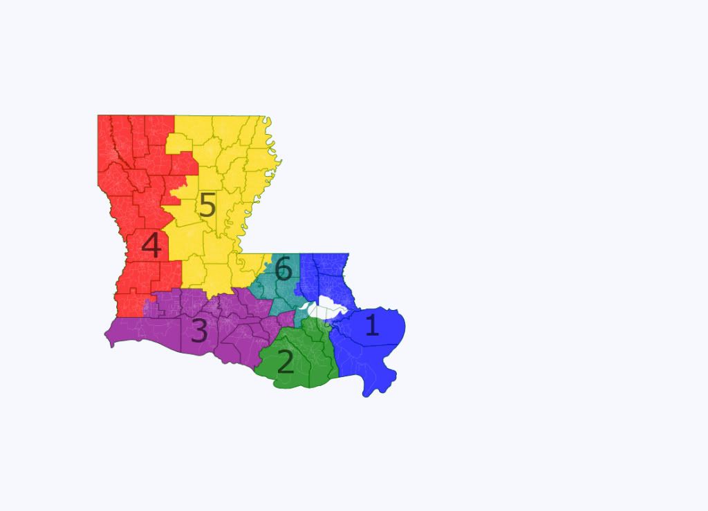
District info:
LA1: most of New Orleans and north-shore suburbs. R+10.1 based on 2008.
LA2: southern end of New Orleans and western suburbs, plus the Thibodaux-Houma area to the south. R+11.1.
LA3: Cajun country. R+15.3.
LA4: Shreveport and the northwest. R+15.2.
LA5: the northeast, including Monroe and Alexandria. R+15.1.
LA6: Baton Rouge and environs. R+10.1.
The 3 southeastern districts might not be completely safe, but they are no less safe than the current districts which are mostly in the R+10 to R+14 range.
Mississippi
To draw a clean 4R-0D map in Mississippi, separate the Dem pocket of Jackson from the mostly blue delta counties. The map:
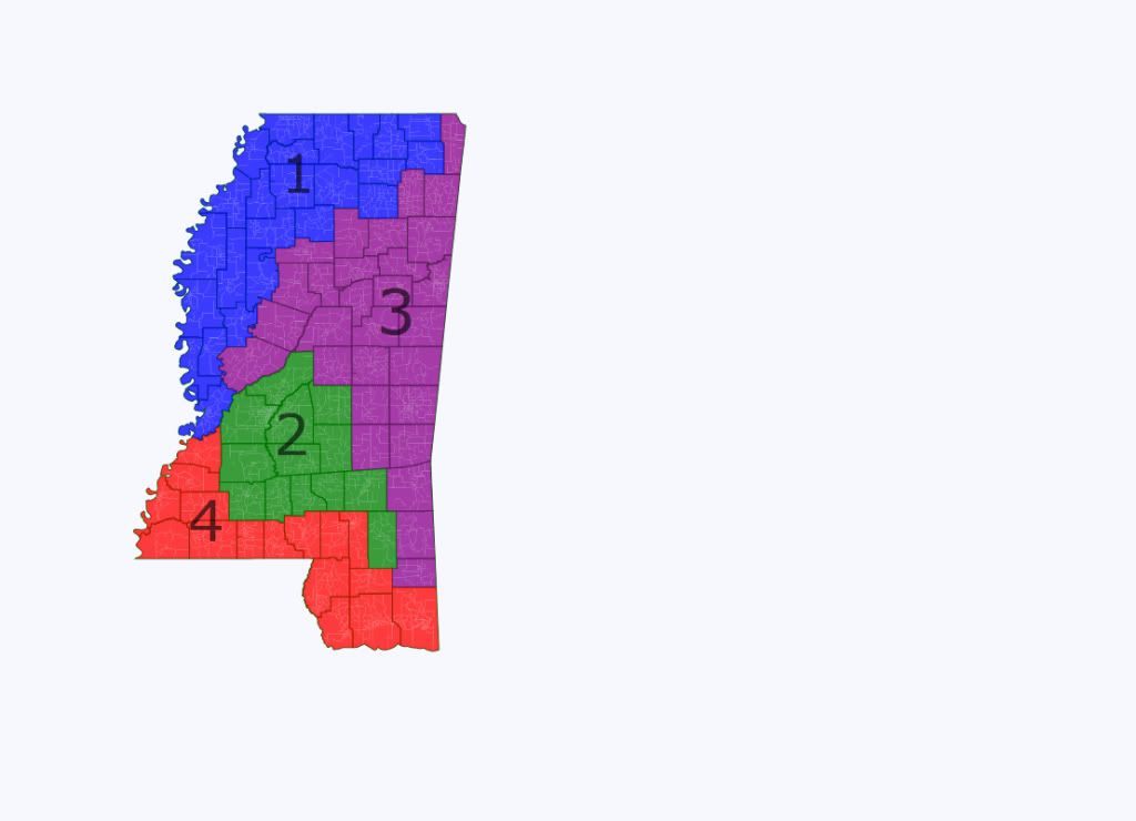
MS1: northwest. R+7.0 based on 2008.
MS2: Jackson and the south-central part of the state. R+7.7.
MS3: east. R+11.0.
MS4: south. R+15.8.
These districts are less safe than the state's 3 current red districts, which range from R+14 to R+20 (and themselves have recently been represented by Travis Childers and Gene Taylor). MS1 and MS2 in particular would be susceptible to Dems in the Childers-Taylor mold, but there's no way to draw 4 totally safe districts. All 4 of these proposed districts would favor the GOP. If on average they can win them 75% of the time, they will be better off than under the current map where they have a ceiling of 3 seats.
Alabama
Obama got just 10% of the white vote in Alabama according to the 2008 exit poll, making it about as polarized by race as Mississippi (11%) or Louisiana (14%).
http://www.cnn.com/...
DRA does not report presidential data for Alabama, but as a first approximation white = red, black = blue. It's straightforward to draw a probable 7R-0D map with no ugly districts by splitting the black sections of Birmingham among two districts and the state's “black belt” running roughly at Montgomery's latitude among four. The map:
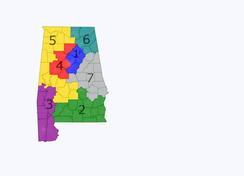
District info:
AL1: The northeastern half of Birmingham and some very white suburbs and exurbs to the east. 74% white, 21% black VAP.
AL2: Montgomery to the Florida border. 60% white, 34% black VAP. Bobby Bright would have a chance here, but in most circumstances it should favor the GOP.
AL3: Mobile and a few rural counties to the north. 67% white, 27% black VAP.
AL4: The southwestern half of Birmingham and some very white counties to the north and west. 64% white, 31% black VAP but it might not be safe R as it contains the college town of Tuscaloosa which probably has a disproportionate share of the state's handful of white liberals.
AL5: The state's very white northwest corner and most of the western half of the black belt. 75% white, 20% black VAP.
AL6: Huntsville, Gadsden, and the northeast corner. 75% white, 20% black VAP.
AL7: Basically the mid-eastern part of the state. 69% white, 26% black VAP.
AL2 and AL4 might be vulnerable to a locally popular blue dog Dem running a strong campaign in a blue wave year, but the other 5 districts are probably hopeless.
Georgia
Georgia is not like the other deep south states: it isn't nearly as far to the right, as Obama got 47% there including 23% of the white vote. If you draw 14 47% Obama (about R+6) districts, Dems would be able to compete in all of them and would probably win 3-6 of them outright in an average year. The Atlanta area in particular has been moving left lately as it draws in young people who are non-southern and/or nonwhite, offsetting the rightward drift of most of the rest of the state. In my view the GOP would have to cede two Atlanta seats to the Dems, leaving 12 districts that they can dominate at least in the near future.
State map:
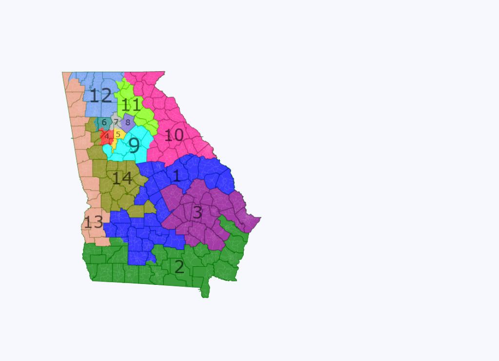
Atlanta closeup:
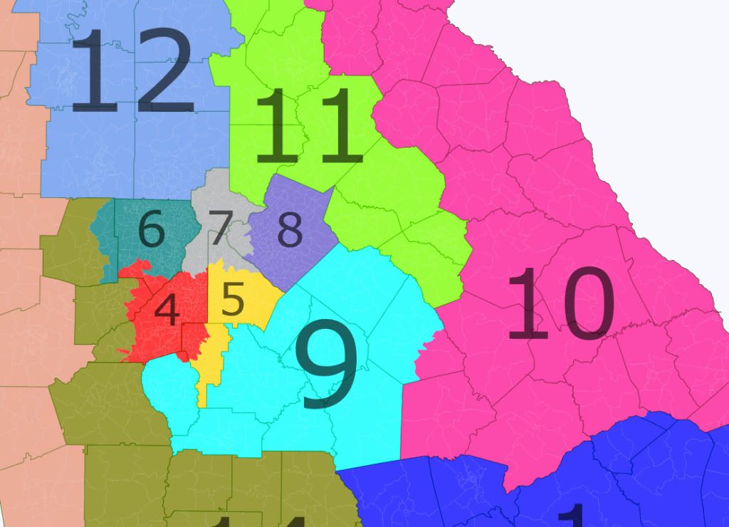
District info:
GA1: Has to zig and zag across south Georgia to offset Dem pockets with safe red areas. R+10.6 based on 2008.
GA2: southern tier. R+10.3.
GA3: offsets the blue city of Savannah with deep red rural counties. R+10.7.
GA4: Fulton county Dem sink. D+33.5.
GA5: DeKalb county Dem sink. D+32.9.
GA6: mostly Cobb county less its bluest precincts. R+13.0.
GA7: mostly the richer parts of Fulton county. R+11.3.
GA8: most of Gwinnett county. R+10.1.
GA9: southern exurbs. R+11.6.
GA10: blood-red suburbs and rurals overwhelm the blue city of Augusta. R+13.4.
GA11: Mostly deep red northern exurbs and rurals, and the unhappy blue college town of Athens. R+21.5.
GA12: More northern exurbs and rurals. Just 4% black. R+26.5.
GA13: All your Alabama border are belong to us. South end is blue, rest is deep red. R+12.1.
GA14: Macon (blue) and western exurbs and rurals (mostly red). R+10.9.
The three northern suburban districts have been trending blue and would likely be competitive by the end of the decade if not sooner, but that would still leave the GOP with a 9-5 edge if everything goes wrong. For now it's a safe 12-2.
South Carolina
South Carolina lacks a white-collar magnet comparable to Atlanta but nonetheless has also attracted migrants from the north. As such its white population is less monolithically red (26% Obama by the exit poll) than the three western deep south states. Also unlike these states, it has not trended red lately and instead has been around R+8 for the last 6 presidential elections. Obama actually beat the Dem average in all 7 districts. Unlike the other maps I've drawn here, most of these districts aren't safe R and the Dems would be able to compete right away in 5 of them. In practice the GOP might be better off doing what they actually did and drawing a sink for Jim Clyburn. If they wanted to roll the dice and go for a clean sweep, they could do this:
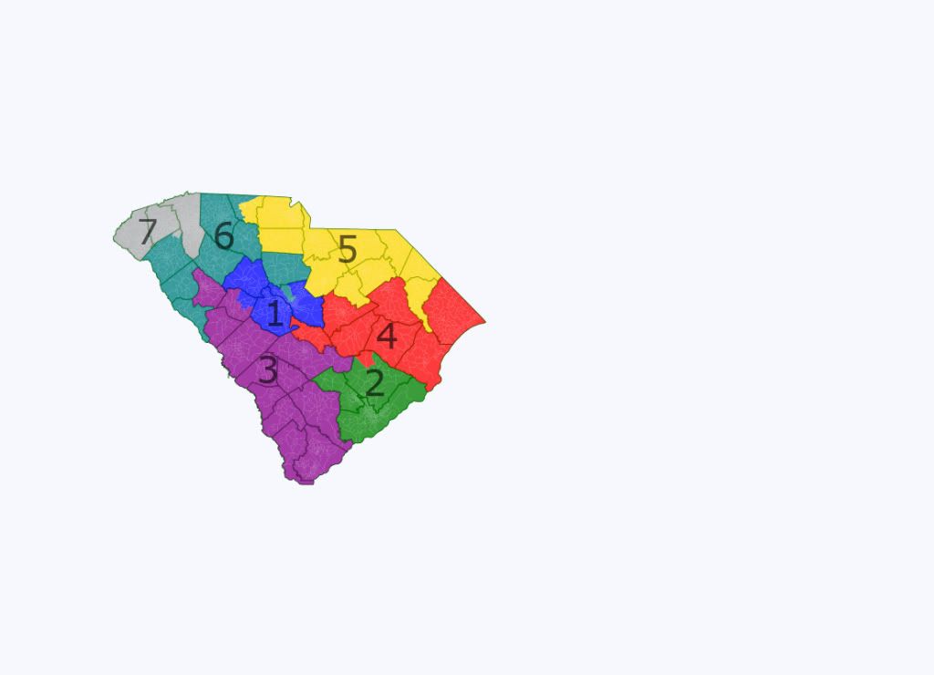
District info:
SC1: most of the Columbia area. R+5.5, likely R.
SC2: Charleston. R+4.5, also likely R.
SC3: the southern end. R+4.7, another likely R.
SC4: Myrtle Beach and some interior counties. R+5.9, likely R.
SC5: northern tier. R+6.6, probably just likely R.
SC6: mostly red upland area, but cracks Columbia to make SC1 more red. R+11.3.
SC7: Greenville. Few Dems here. R+18.5.
Without the VRA the Dems would probably be assured of just 2 or 3 (if SC drew a sink for Clyburn) House seats in the Deep South as opposed to the 8 they should have under the 2012 maps, but they would also probably have a better (if still slim) chance to compete in some of the red districts.
